Sylhet Fm
Type Locality and Naming
Middle formation of the Jaintia Gr. Type section is in the Um Sohryngkew river section in the south of Cherrapunji. [Original Publication: Medlicott, H. B., 1869. Geological Sketch of the Shillong Plateau, Mem. Geol. Surv. India, vol. VII, pt.1, pp.151-207.]. Reference well: Lakwa Well 351 (depth interval: 4836 to 4966 m) and Domjur Well – 1 (depth interval: 3845 to 4640 m). 130 m thickness in Lakwa Well, 351 and 795 m thickness in Domjur Well – 1.
Synonyms: Sylhet Limestone Fm. The sequence of fossiliferous limestones alternating with sandstones outcropping along the southern edge of the Shillong Plateau was first named as Nummulitic series by Medlicott (1869). Evans (1932) used the name Sylhet Stage for the limestone-sandstone sequence of the South Shillong shelf. Ghosh (1964) demonstrated that a part of this limestone and overlying sandstone in the Therria Ghat area corresponds to a facies of the Cherra lithotype and mapped the same as Cherra band. This constitutes the Therria Limestone and Therria Sandstone of the Sylhet Formation (Wilson & Metre, 1953) which is followed upward by another limestone-sandstone pair the Lakadong Limestone and Lakadong Sandstone; which is succeeded by Umlatodoh Limestone, Narpurh Sandstone and Prang Limestone till the succession is capped by the Kopili Fm. Thus the Sylhet Limestone has five members: Therria, Lakadang, Umlatodoh, Narpurh and Prang. The lower two of these are composed of two lithotypes each – the limestone followed by sandstones while the upper three are individually named units. Wilson and Metre (1953) thus recognized the Lakadong Limestone, Lakadong Sandstone, Umlatdoh Limestone, Nurpuh Sandstone and Prang Limestone, from base to top as distinct lithological units of the Sylhet Formation. This classification has been followed by subsequent workers, with lithostratigraphic status of members. The limestone sequence exposed in the Garo Hills was named as Siju limestone by Fox (1937) which was later correlated with Prang Limestone Member of Khasi and Jaintia Hills on the basis of fossil evidence (Chandra and Basu, 1959). In the Mikir Hills and in the subsurface of Upper Assam and Dhansiri Valley, the Sylhet Formation is not differentiated into various members as in the southern Shillong shelf (Pandey and Dave 1998).
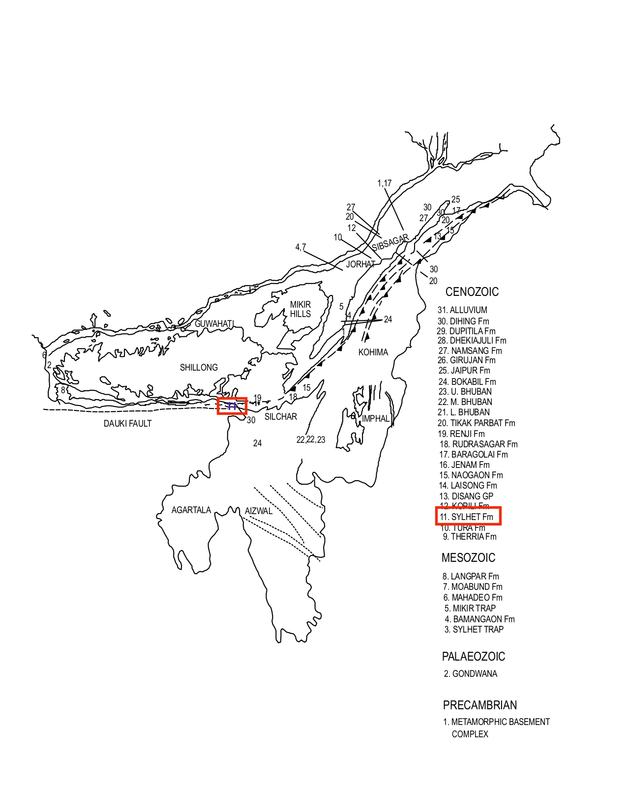
[Figure 1: Formation stratotypes of North East Basins (modified after Pandey and Dave, 1998)
Lithology and Thickness
Limestone and sandstone. Type section lithology: In the Um Sohryngkew section, the following succession is observed (Deshpandey et al., 1993). Therria Limestone/Sandstone 65 m, Bedded Limestone, mottled Sandstone 26 m. Limestone: highly fossiliferous, massive, 144 m. Sandstone: medium to coarse grained, 18 m. Limestone: dark grey Alveolina bearing 83 m. Sandstone: fine to coarse grained, coal bearing, 24 m. Limestone: greenish and pinkish grey, massive fossiliferous 163 m. Reference section lithology: In well Lakwa 351, it includes a sequence of limestones and calcareous shales. The percentage of shale decreases towards top. The limestones are bioclastic, pink, buff to green colored. Succession in the West Bengal reference section Domjur – 1 includes thick compact limestones separated by thin clastics (Pandey and Dave 1998).
MEMBER(S)–This unit has been divided into five members in descending order namely (Sarmah and Borgohain, 2012).
5) PrangLmsMbr Fm = uppermost member
4) NarpuhSstMbr Fm
1) LakadongLmsMbr Fm = lowermost member
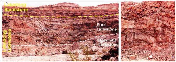
[Figure 2: Field photographs of the Lakadong Mbr of Sylhet Fm exposed in Mawmluh Limestone Quarry near Cherrapunji. a, Panoramic view showing the Lakadong Formation; b, Dolomite between benches. (after Tewari et al., 2010)
Relationships and Distribution
Lower contact
This formation conformably overlies Langpar Fm or Tura Fm (e.g., SE Bangladesh) or Cherra Fm (usage in NW Bangladesh) with a gradational contact.
Upper contact
Grades upwards into the Kopili Fm.
Regional extent
The outcrops of the Sylhet Formation are found all along the southern edge of the Shillong Plateau from Tura village in the west to Balichara river in the east, northwards the Sylhet outcrops are seen in the Kopili valley, along the southern fringes and in the down-faulted block along the Khunbaman uplift in Mikir Hills. These continue further east and northeast wards along the fringes of Mikir Hills up to Nambar Nadi. The presence of Sylhet Formation continues to extend in the subsurface of Dhansiri Valley and Upper Assam and in the sub-thrust block of Schuppen Belt (Deshpandey et al., 1993). In the subsurface of West Bengal, the formation is encountered in all the wells drilled to this level except Bolpur-1. In the well Domjur-1, it is encountered between 3845 m and 4460 m depth. At places, it attains a thickness of over 1000 m (Chandra et al., 1983). There are marked variations in the thickness and continuity of individual limestone and sandstone bands in the Shillong Plateau. The topmost is fairly continuous of all and can be traced along South Shillong Plateau without much change in the lithological characteristics. The lower limestone bands rapidly pinch out towards north and west of the type area, the lowest band is more extensive than the middle band. The intervening sandstones become coarser and more ill sorted towards the margin i.e., north and develop coal seams (Pandey and Dave 1998). In Bangladesh subsurface, the Syhlet Fm limestone is a major reflector.
GeoJSON
Fossils
Sylhet Formation contains rich microfauna in the Shillong Plateau is varied and includes several species of larger foraminifera. In the remaining part of the shelf area fauna equivalent of the Prang Limestone Member are recorded (Pandey and Dave 1998).
Age
Depositional setting
In the Shillong Plateau it represents deposition in a shallow shelf area, the carbonate sedimentation being interrupted by either changes in sea level or short pulses of increased clastic supply. In the remaining part of the shelf area it represents deposition in a shallow shelf deepening towards northeast and south of the Mikir Hills and eastward in Bengal Shelf (Pandey and Dave 1998).
Additional Information

